Photo Log: Baja California Highway 5 Update - February 2019
Here's a quick update of the road conditions of Baja California Highway 5 from Laguna Chapala north to Puertecitos. The storms of Fall 2019 have done some major damage to the area but the locals always figure a way around obstacles.
Remember, this is driving north from Laguna Chapala (at the Highway 1 intersection) to Coco's Corner then to Bahia San Luis Gonzaga and then one to Puertecitos (south of San Felipe).
Some sections have rough washboard and rock slides. Others have highway and road ways missing, some marked some not, that you need to go around. And then there are a number of bridges out.
Please use extreme caution when driving this section. It's doable but slow.
Photos taken on February 3rd, 2019.
Thank you to Baja Bound Insurance Services for making this trip possible.
Remember, this is driving north from Laguna Chapala (at the Highway 1 intersection) to Coco's Corner then to Bahia San Luis Gonzaga and then one to Puertecitos (south of San Felipe).
Some sections have rough washboard and rock slides. Others have highway and road ways missing, some marked some not, that you need to go around. And then there are a number of bridges out.
Please use extreme caution when driving this section. It's doable but slow.
Photos taken on February 3rd, 2019.
 | ||
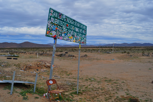
| Here is the stickered sign at the turn off of "Highway 5" |
 |
| The first couple hundred yards off of Highway 1 is paved, but that's fool's gold as the road is rough with washboard and rock slides to follow. |
 |
| Car-sized boulders have fallen off the cliffsides. |
 |
| Coco's Corner sign and construction equipment. |
 |
| Long washboard section just before you turn north to Coco's Corner. |
 |
| Coco's Corner - Stop in, say hi to Coco, sign his book and buy a cerveza. |
 |
| The road is so rough in some spots that the locals have already made their own side roads in the soft sand. |
 |
| The bridges south of Gonzaga Bay are intact. |
 |
| This is not a copy of the photo above, it's another section north of Coco's with rock slides. |
 |
| Finally! Pavement just south of Bahia San Luis Gonzaga. |
 |
| Army checkpoint just north of Gonzaga Bay and Papa Fernandez'. |
 |
| Soon after you will begin to see cones marking small areas of missing road. This is nothing compared to what's coming your way. |
 |
| Water is amazing and destructive as you can see in the arroyo that completely destroyed the embankments of this bridge. Unfortunately this type of contruction will never route the water properly. |
 |
| With large sections of roadway and bridges out, the locals have made their own roads as in the past. Even detours large trucks can access. |
 |
| A closer shot of the damage that large rain storms can do. |
 |
| Completely missing sections of highway looking south. |
 | |
| Cross section of highway completely gone. |
 |
| Cones warn of a portion of a missing bridge. In some sections there are no cones, just tires or debris piles. Be cautious. |
 |
| The largest span we came across is falling apart. Do not drive on it, follow the locals around these damaged bridges. |
 |
| Another shot looking south of the same bridge from the detour. |
 |
| Cones, tires and debris all mark damaged highway. Beware, it's difficult to see at night. |
Thank you to Baja Bound Insurance Services for making this trip possible.


Comments